This article contains advertising. Our booking links are routed through a partner that adds commission tracking automatically, so if you book through one we earn a commission from the provider, at no extra cost to you. It never affects what we recommend. Affiliate disclosure
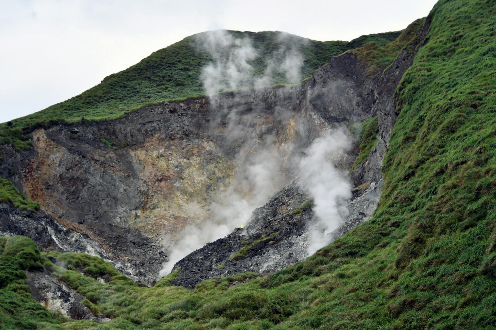
You smell the start of the trail before you see it. Step off the bus at Xiaoyoukeng and the air carries a tang of rotten eggs; walk to the edge of the car park and there it is, a raw yellow-grey scar on the side of the mountain, hissing with steam. The path to the top of Qixing Mountain starts right beside it and climbs straight up the flank of a dormant volcano, through silver grass and dwarf bamboo, to a rocky summit 1,120 metres above the sea. It is the highest point in Taipei City and the crown of Yangmingshan National Park, and you can reach its trailheads by bus from the MRT.
This guide covers the climb in detail: the four routes up and which to choose, how long each takes, what you see from the Main Peak and the East Peak, how to get there by bus, the weather that makes or breaks the day, safety on an exposed volcanic summit, and how to combine the hike with the rest of Yangmingshan. Details were checked in October 2026; confirm times and fares with the operators before you go. For the park as a whole, see our Yangmingshan National Park guide; for the bigger picture, our guide to hiking in Taipei.
Qixing Mountain at a glance
| The short version | |
|---|---|
| Height | Main Peak 1,120 m, the highest point in Taipei City; East Peak 1,107 m |
| Where | Yangmingshan National Park, on Taipei’s northern edge |
| Best route | Up from Xiaoyoukeng, over the Main and East Peaks, down to Lengshuikeng |
| Time | Up and back from Xiaoyoukeng is the short option; the traverse takes longer |
| Difficulty | Moderate: steep, stepped and relentless, but never technical |
| Getting there | Bus R5 from Jiantan station to the Yangmingshan bus terminal, then the 108 park bus |
| Best time | Clear mornings from October to December; early starts in summer |
| Cost | Free, apart from the buses |
What things cost
| Item | Typical cost (September 2026) |
|---|---|
| MRT to Jiantan station | Roughly NT$20–30 with an EasyCard |
| Bus R5 up to the park, and the 108 park bus | City bus fares, from NT$15 per section |
| National park entry, trails and visitor centres | Free |
| Water and snacks bought in the city before you go | Roughly NT$50–100 |
| Taxi from the city to Xiaoyoukeng | Several hundred NT$; fine for a group, pricey alone |
| A hot spring in Beitou afterwards | From a few hundred NT$ for a public or hotel bath |
Taipei’s highest peak
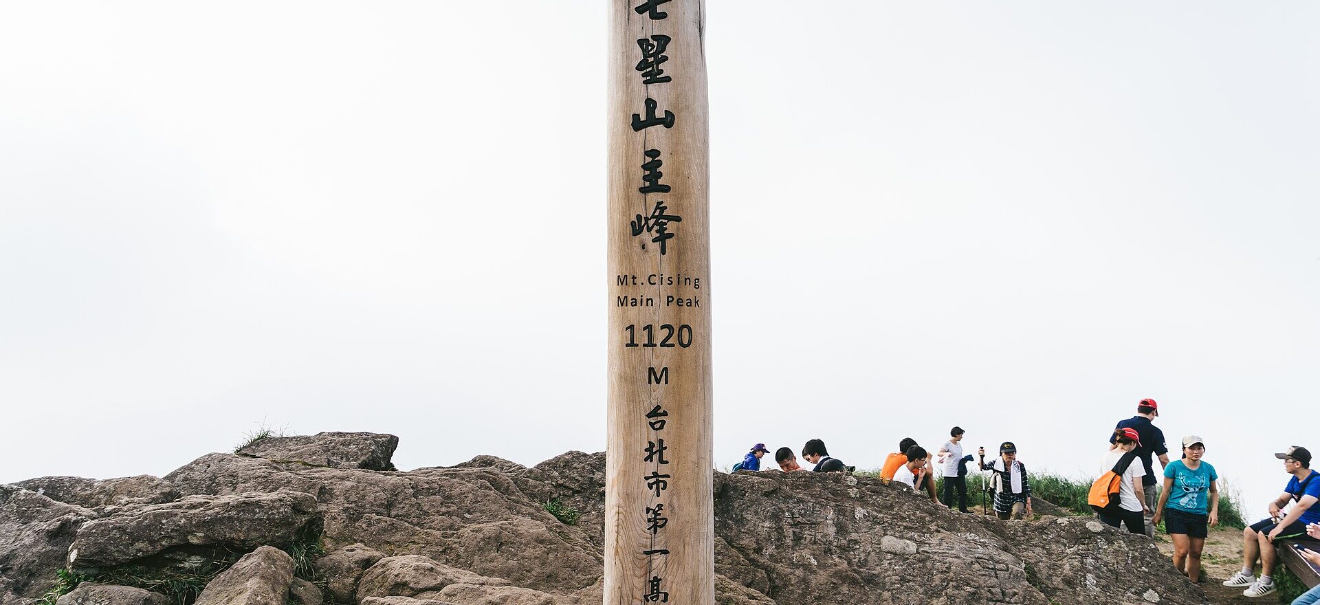
Qixing Mountain (七星山, “Seven Star Mountain”, also spelt Cising or Chihsing on older signs) is the tallest of the dormant volcanoes of the Datun volcano group, which rises along the northern rim of the Taipei basin and makes up most of Yangmingshan National Park. The name is usually explained as a reference to the cluster of small peaks and cones around its summit. It has two tops: the Main Peak at 1,120 metres, marked by a pole engraved with its name and elevation, and the East Peak at 1,107 metres, a short walk along the summit ridge.
What makes Qixing special is not its height — by Taiwanese standards it is a hill, and the island has hundreds of peaks over 3,000 metres — but how much it packs in and how close it is to the city. On one morning’s walk you pass steaming fumaroles and sulphur crystals, climb through open grassland that turns silver and gold in autumn, look down on the whole Taipei basin and out to the sea, and pass a small mountain lake that shelters a plant found nowhere else on Earth. All of it starts from a bus stop.
Choosing your route
Four trailheads lead to the top, and they can be combined into a traverse, since the park bus links them all.
| Route | Character |
|---|---|
| Xiaoyoukeng | The shortest approach, and steep; fumaroles at the start; open views most of the way |
| Lengshuikeng, via the East Peak | Steep forest, then grassland; passes the turn-off for Menghuan Pond |
| Menghuan Pond car park | Joins the Lengshuikeng route; handy if you are driving |
| Miaopu, near the Yangmingshan Visitor Center | The most climbing of any approach, and the most wooded; starts close to the bus terminal |
Our pick: the Xiaoyoukeng–Lengshuikeng traverse
Climb from Xiaoyoukeng, cross the Main Peak and the East Peak, and descend to Lengshuikeng, with a short detour to Menghuan Pond on the way down. The 108 bus links both ends, so there is no retracing your steps, and the national park’s trail pages give the distance and walking time for each section. You climb the steepest side while fresh, get the fumaroles, both summits, the lake and the forest, and finish close to Qingtiangang if you still have energy.
The quick up-and-back from Xiaoyoukeng
If you are short of time or the weather looks uncertain, climb from Xiaoyoukeng to the Main Peak and come back the same way. It is the most popular route by far, and on a clear weekend morning it is busy.
The long way from Miaopu
From the Miaopu trailhead near the Yangmingshan Visitor Center, the trail climbs through forest to the summit, with more ascent than any other approach. It is shadier, and you can walk from the bus terminal without waiting for the park bus. Combined with a descent to Xiaoyoukeng, it makes a crossing of the mountain; allow about three hours.
The climb from Xiaoyoukeng, step by step
The Xiaoyoukeng (小油坑) recreation area sits on the north-western flank of Qixing, where a field of fumaroles sends up a continuous stream of steam. A short boardwalk from the visitor centre looks across at the vents, yellow with sulphur crystals and loud with escaping gas. Stay behind the railings: the ground near the vents is hot and unstable, and the gases are unpleasant at best.
The trail to the summit starts beside the viewing area and gets straight to work. Stone steps and short stretches of rocky path climb steadily up the open slope, with almost no shade. As you gain height, the fumaroles shrink below you and the views open out over the grassland towards Mount Datun and Zhuzihu. The upper slopes are covered in dwarf bamboo and silver grass, which turns a shimmering white and gold in autumn, and in spring the trail has azaleas along its edges. There are a few benches and a pavilion on the way, and the steps rarely let up. Take it slowly — the hardest part is the steady rhythm of the stairs rather than any single steep section.
The final stretch brings you onto the summit ridge. The Main Peak is a jumble of volcanic boulders around the tall wooden marker post; the East Peak lies a little further along the ridge, on the way down to Lengshuikeng.
On the summit
On a clear day, the view from the Main Peak is the reward for the climb. Below you, the Taipei basin spreads out; to the west, the Tamsui River winds past Guanyin Mountain; and to the north, the land falls away to the coast near Jinshan. Much closer, the green cones and grasslands of the rest of Yangmingshan fill the foreground.
That is on a clear day. On many days, especially in winter and spring, the summit is in cloud, and you will see the marker post, a few boulders and a lot of white. It is still a satisfying climb, and the clouds sometimes tear open for a few minutes at a time, but if the view is the point, check the weather before you set out.
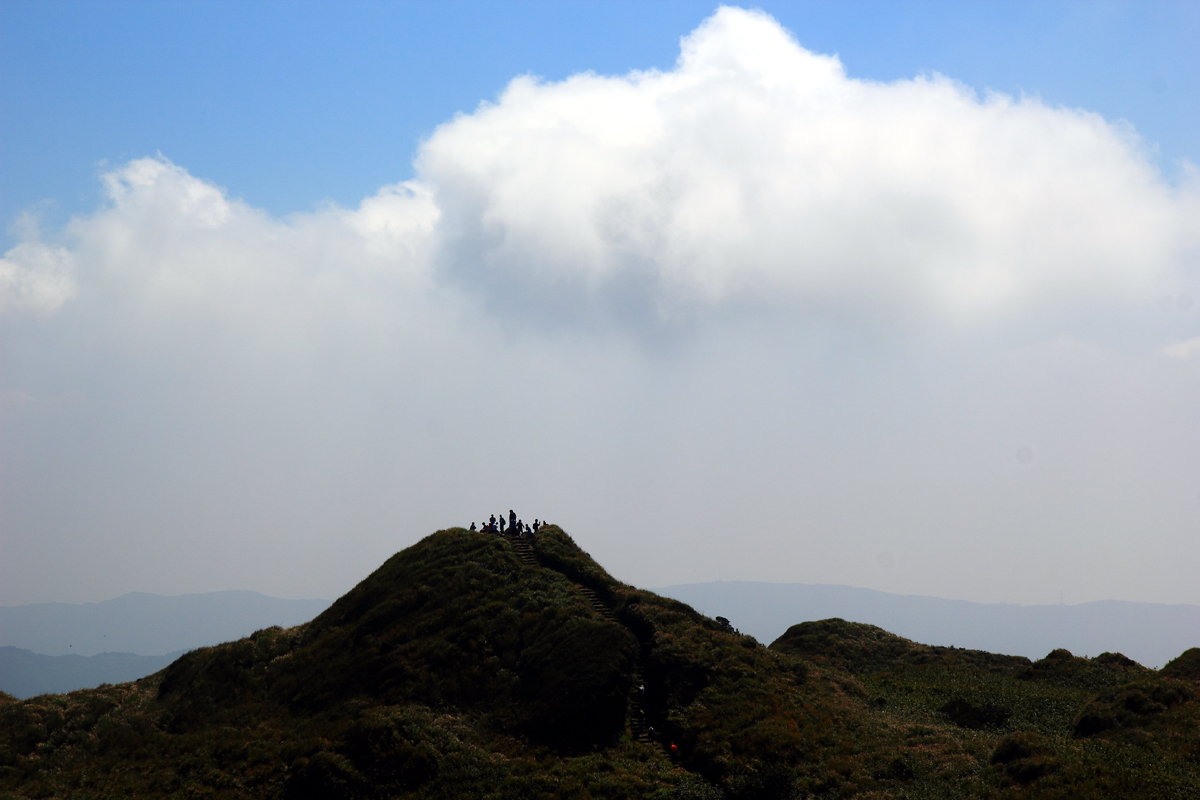
The East Peak, a short walk along the ridge, is a smaller, grassier summit, and it is often quieter. From here the trail drops steeply towards Lengshuikeng. Allow time on both tops; the summit ridge is the best part of the walk.
Menghuan Pond: the dream lake
On the descent towards Lengshuikeng, a short side trail leads to Menghuan Pond (夢幻湖, “Dream Lake”), a small, reedy lake in a hollow on the mountain’s flank, often wreathed in mist, which is how it got its name. It is home to the Taiwan quillwort (台灣水韭), a small, grass-like aquatic plant found wild only here, and the pond is a protected ecological area: stay on the boardwalk and the viewing platform, and do not touch the water.
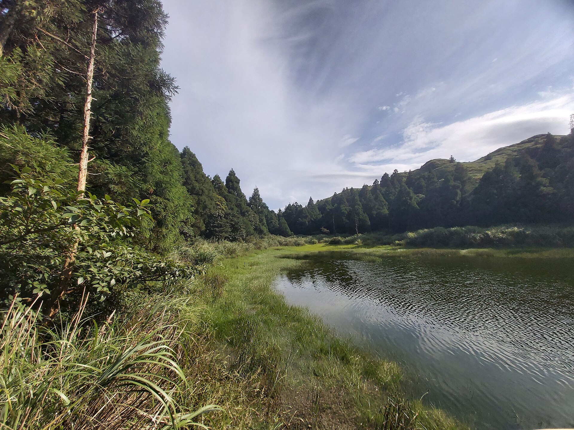
From the pond, it is a short walk down through the forest to Lengshuikeng (冷水坑, “cold water pit”), where there is a visitor centre and the stop for the 108 bus. Lengshuikeng’s springs have long drawn bathers to its public bathhouse and foot-soaking pool, but opening arrangements have varied over the years, so check before you count on a soak here.
Getting to Qixing Mountain by bus
You do not need a car. From central Taipei:
- Bus R5 (紅5) runs from Jiantan station on the Red Line to the Yangmingshan bus terminal. Bus 260 also runs up from the Taipei Main Station area.
- From the bus terminal, the 108 park bus loops through the park, calling at Xiaoyoukeng, Lengshuikeng, Qingtiangang, Zhuzihu and other stops. It is the link between trailheads if you walk a traverse.
- Bus 1717, which runs across the mountains to the north coast on the Yangjin Highway, also passes Xiaoyoukeng; check the timetable, as it is much less frequent.
- For Miaopu, walk from the bus terminal to the trailhead by the Yangmingshan Visitor Center.
Buses fill up on sunny weekends and in the spring flower season, and queues for the R5 at Jiantan can be long in the morning. Go early, or go on a weekday. Our Taipei bus guide explains how to pay and when to tap your card, and our Yangmingshan day trip guide has a full itinerary.
Driving is possible, but parking at Xiaoyoukeng and Lengshuikeng fills early at weekends, and the mountain roads jam in flower season. A taxi from the city is a reasonable option for a group of three or four.
Weather and the best time to climb
Qixing makes its own weather. The summit is usually five to ten degrees cooler than central Taipei, it catches the wind and the cloud, and conditions can change in minutes. The source of record for forecasts is the Central Weather Administration, which publishes forecasts for the national parks.
- October to December: the best season. Drier air, the clearest views of the year and the silver grass at its finest. The northeast monsoon brings more wind and cloud as winter approaches, so pick a clear day after a front has passed.
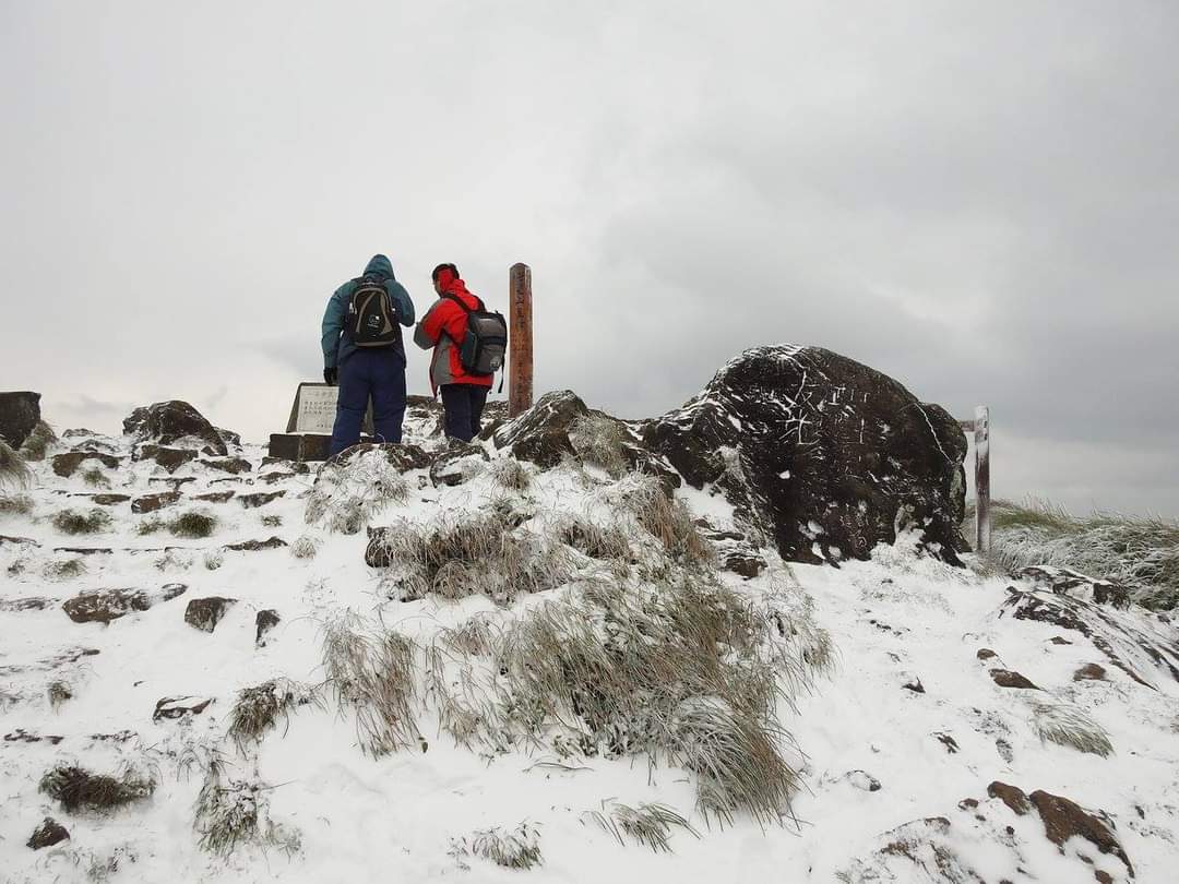
- January and February: often cold, damp and misty on the summit, with strong winds. During the strongest cold surges, Qixing is one of the few places near Taipei that can get a dusting of snow — a rare event that brings half the city up the mountain.
- March and April: spring flowers, azaleas along the trail and changeable weather.
- May and June: the plum rains, with frequent heavy showers and poor visibility.
- July to September: hot and humid, even at the top, with afternoon thunderstorms and typhoons. Start by 07:00 and be off the summit by late morning.
Staying safe on an exposed summit
- Thunderstorms. The upper mountain is open grassland and rock, on the highest peak in Taipei City. If thunder starts, head down at once; do not shelter on the summit.
- Wind and cold. Even on a mild day in the city, the summit can be windy and chilly. Carry a windproof layer.
- Fog. In cloud the grassland looks the same in every direction. Stay on the stepped path; it is easy to follow if you do.
- Volcanic gases. Keep to the boardwalks and paths around Xiaoyoukeng. Areas closed off with fences and warning signs are closed for good reason.
- Heat. The Xiaoyoukeng route has almost no shade. In summer it is a serious climb; carry plenty of water and start early.
- Wet rock. The summit boulders and the steps get slippery after rain.
- Emergencies. Dial 119. Mobile coverage is good on most of the mountain.
The national park posts trail closures after typhoons and heavy rain on its official website. If a trail is closed, it is closed for a reason.
What to bring
- Water: at least a litre per person, more in summer. There is nowhere to buy it on the trail.
- Food: snacks or a packed lunch. Food options in the park are limited; buy supplies in the city.
- Shoes with grip: trainers are fine in dry weather; walking shoes are better when it is wet.
- A windproof, waterproof layer, whatever the forecast says in the city.
- Sun protection: a hat, sun cream and sunglasses for the open slopes.
- An EasyCard with enough credit for several bus rides.
- A bag for rubbish: carry everything out.
Visitor centres, toilets and food
The park’s visitor centres at Xiaoyoukeng, Lengshuikeng and the main Yangmingshan Visitor Center have toilets, maps and exhibitions, and staff can tell you about trail conditions. The Xiaoyoukeng and Lengshuikeng centres open daily from 09:00 to 16:30 and close on the last Monday of each month (and the following Tuesday if that Monday is a public holiday) and on Lunar New Year’s Eve; the main visitor center at the park headquarters opens earlier, at 08:30. Toilets are at the trailheads, not on the mountain.
Food in the park is limited to the odd snack stall and a handful of restaurants on the roads, many serving free-range chicken and mountain vegetables to weekend drivers. Bring what you need, and plan a proper meal back in the city — Shilin Night Market is by Jiantan station, where the R5 drops you off.
Combining Qixing with the rest of Yangmingshan
Qixing sits at the centre of the park, and a good day combines it with one or two other stops:
- Qingtiangang: after descending to Lengshuikeng, walk on, or ride the 108, to the Qingtiangang grassland, where water buffalo graze along an easy circular trail; allow about an hour for the full loop.
- Zhuzihu: the valley below Qixing’s western flank, famous for calla lilies in spring and hydrangeas in early summer.
- Beitou: the natural end to a Yangmingshan day. Take the bus down the mountain to Beitou for a hot spring soak — see our Beitou hot springs guide — then ride the MRT back into the city.
A sample day on the mountain
| Time | What to do |
|---|---|
| 07:15 | MRT to Jiantan; bus R5 up to the Yangmingshan bus terminal |
| 08:15 | The 108 park bus to Xiaoyoukeng; look at the fumaroles from the boardwalk |
| 08:30 | Start the climb; allow an hour to an hour and a half to the Main Peak |
| 10:00 | Main Peak, then along the ridge to the East Peak |
| 11:00 | Down towards Lengshuikeng, with the detour to Menghuan Pond |
| 12:00 | Packed lunch at Lengshuikeng, or walk on towards Qingtiangang |
| 13:30 | The Qingtiangang grassland loop, about an hour |
| 15:00 | The 108 back to the terminal and a bus down to Beitou |
| 16:30 | A hot spring soak in Beitou, dinner, and the MRT home |
In summer, shift everything an hour earlier and plan to be off the summit before the midday heat and the afternoon storms.
Sunrise, sunsets and seas of cloud
Qixing’s summit is famous for the “sea of clouds” (雲海), when low cloud fills the Taipei basin and the peaks of Yangmingshan float above it like islands. It happens most often on cool, still mornings in autumn and winter, usually early, and it is the picture every Taiwanese hiking photographer wants. The catch is timing: check the first-bus time before you plan a dawn summit, which may well mean a taxi, a car or a scooter and a head-torch climb in the dark. For most visitors, an early bus and a clear autumn morning are a better bet — the clouds often linger in the valleys until mid-morning.
Sunset on the summit is beautiful but leaves you descending in the dark and relying on the 108 to get back. If you go up for sunset, check the last departure from the trailhead you are walking down to, and carry a torch.
Park rules worth knowing
- Stay on the trails. The grasslands and the ground around the fumaroles are fragile, and the vents are dangerous.
- Take nothing, leave nothing. Picking plants, collecting sulphur crystals and feeding wildlife are prohibited in the national park, and there are no bins on the trails.
- Drones need permission. Flying over the national park is restricted; check with the park before you bring one.
- No fires or camping on the mountain.
- Keep dogs on a lead, if you are walking with one, and away from Menghuan Pond.
Qixing Mountain with children
Fit children who are used to walking can manage the Xiaoyoukeng route, and they tend to love the steaming fumaroles, but the steps are relentless and there is little shade, so turn back without guilt if energy runs out. For younger children, the boardwalk at Xiaoyoukeng, the Qingtiangang loop and the flat Erziping trail on the western side of the park are better choices. Pushchairs cannot be used on the summit trails. For more ideas, see our guide to Taipei with kids.
What we would skip
- The summit in thick cloud, if you are going for the view. Check the forecast; on a grey day, walk Qingtiangang instead.
- The midday climb in summer. The Xiaoyoukeng slope is an open staircase in full sun. Go at dawn or choose a forest trail.
- Driving up on a sunny weekend in flower season, unless you enjoy queues for parking. Take the bus and go early.
- Chasing snow. When a cold surge brings a forecast of snow, the mountain roads jam and are sometimes closed. It is a spectacle best watched on the news.
- Leaving the path to reach the fumaroles or cut corners on the grassland. The ground is fragile and, near the vents, dangerous.
Related Taipei guides
- Hiking in Taipei: Best Trails, Beaches & Outdoor Escapes
- Yangmingshan National Park
- Yangmingshan Day Trip
- Beitou Hot Springs Guide
- Beitou District Guide
- The Four Beasts Hike
- Elephant Mountain Hike
- Cherry Blossoms in Taipei
- Shilin Night Market
- Taipei in Autumn
Frequently Asked Questions
How high is Qixing Mountain?
The Main Peak is 1,120 metres, the highest point in Taipei City. The East Peak, a short walk along the summit ridge, is 1,107 metres.
How long does it take to climb Qixing Mountain?
Xiaoyoukeng is the shortest route to the Main Peak, a steep climb on stepped trail. A crossing from Xiaoyoukeng over both peaks and down to Miaopu takes about three hours; the Yangmingshan National Park site gives the walking times for the other routes and sections.
Which is the best route up Qixing Mountain?
For most people, climb from Xiaoyoukeng, cross the Main and East Peaks and descend to Lengshuikeng, with a detour to Menghuan Pond. The 108 park bus links both ends. For a shorter day, go up and back from Xiaoyoukeng.
How do I get to Qixing Mountain by public transport?
Take the MRT to Jiantan station, then bus R5 to the Yangmingshan bus terminal. From there, the 108 park bus goes to Xiaoyoukeng and Lengshuikeng. Bus 260 from the Taipei Main Station area also reaches the terminal.
Is Qixing Mountain hard to climb?
It is moderate: steep and stepped all the way, with around 300 metres of climbing from Xiaoyoukeng, and the open ground near the Main Peak can be battered by strong winds. Reasonably fit walkers manage it easily; the heat in summer and the wind in winter are the main challenges.
When is the best time to hike Qixing Mountain?
October to December, on a clear day after a cold front, for the best views and the silver grass. In summer, start by 07:00 to avoid the heat and the afternoon thunderstorms. Avoid it in thick cloud if the view matters to you.
Is Qixing Mountain a volcano?
Yes. It is the tallest of the dormant volcanoes of the Datun volcano group, which makes up most of Yangmingshan National Park. The steaming fumaroles at Xiaoyoukeng, on its flank, are the most visible sign that it is still warm underneath.
Can you see Taipei 101 from Qixing Mountain?
On a clear day the summit looks out over the Taipei basin, where the city spreads below you, and west to the Tamsui River and Guanyin Mountain. On cloudy days, which are common, you may see nothing at all.
Does it snow on Qixing Mountain?
Occasionally, during the strongest winter cold surges. It is rare and brief, and when it happens the mountain roads fill with sightseers. Most winter days bring cold wind, drizzle and fog instead.
What is Menghuan Pond?
Menghuan Pond, or “Dream Lake”, is a small, often misty lake on Qixing’s flank above Lengshuikeng. It is the only home of the Taiwan quillwort, a rare aquatic plant, and is a protected area — view it from the boardwalk.
Are there toilets on the Qixing Mountain trail?
At the trailheads only: the visitor centres at Xiaoyoukeng and Lengshuikeng and the main Yangmingshan Visitor Center. They open 09:00–16:30 and close on the last Monday of each month.
Can I do Qixing Mountain and Beitou in one day?
Yes, and it is a classic combination. Climb Qixing in the morning, take the bus down the mountain in the afternoon, and finish with a hot spring soak and dinner in Beitou before taking the MRT back into the city.
The Bottom Line
Qixing Mountain is the one proper summit every visitor to Taipei can reach without a car or a guide. In a morning you climb past steaming volcanic vents, through silver grass and dwarf bamboo, to a rocky top 1,120 metres up — then walk over a second peak, past a misty lake with a plant found nowhere else, and catch the bus down for a hot spring soak. Pick a clear day, start early, carry a windproof layer and plenty of water, and walk the traverse from Xiaoyoukeng to Lengshuikeng. On a good day it is the finest walk within reach of the city.
Photo Credits
The Main Peak marker on Qixing Mountain: Mt. Qixing Main Peak 20151108 by 翁維德 (Wei-Te Wong), CC BY-SA 2.0, via Wikimedia Commons.
Hikers on the East Peak: Cising mountains, Yangmingshan National Park (七星山東峰) – panoramio by Liu Dyson, CC BY 3.0, via Wikimedia Commons.
Menghuan Pond: Menghuan Lake-01.2023-08-19 by 阿道, CC BY-SA 4.0, via Wikimedia Commons.
Snow on the summit ridge: 七星主峰‧東峰步道雪景12 by 賴亮名, CC BY-SA 4.0, via Wikimedia Commons.